Color Map Layers: Difference between revisions
Jump to navigation
Jump to search
No edit summary |
No edit summary |
||
| Line 12: | Line 12: | ||
== Low Level API == | == Low Level API == | ||
The main API for creating elevation color map layers is through the | The main API for creating elevation color map layers is through the '''IMapLayerViewModel''' interface with the following methods | ||
<source lang="c#"> | <source lang="c#"> | ||
| Line 44: | Line 44: | ||
} | } | ||
} | } | ||
The default implementation of this interface is typically '''TPG.GeoFramework.MapLayer.NativeMapLayerViewModel'''. | |||
</source> | </source> | ||
Revision as of 10:27, 31 May 2021
General
Color map layers, or paletted data layers are single channel data layers, for example elevation data, which can be colored according to a user definable palette. Values in the map data are matched with colors in the palette, and the neighboring values may be interpolated over the span of colors in the palette.
Colors may be mapped directly to data values, or there may be a calculation involved. For example we have the possibility to assign colors based on slope or aspect of elevation data sets.
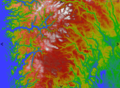
Elevation values
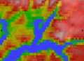
Elevation without smoothing
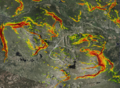
Slope values


Low Level API
The main API for creating elevation color map layers is through the IMapLayerViewModel interface with the following methods
namespace TPG.GeoFramework.MapLayer.Contracts
{
    public interface IMapLayerViewModel : IExportableLayer
    {
       ...
        /// <summary>
        /// Create a named color map layer with the given data provider.
        /// </summary>
        /// <param name="name">Name for the new layer.</param>
        /// <param name="provider">Data provider. </param>
        /// <param name ="paletteId">ID of the palette to be used. This palette name must be available in the given data provider.</param>
        /// <param name="smoothInterpolation">Enable smooth interpolation of the map colors.</param>
        /// <returns>A new raster layer with the given properties.</returns>
        IMapServiceRasterLayerData AddColorMapLayer(string name, IMapDataProvider provider, string paletteId, bool smoothInterpolation = true);

        /// <summary>
        ///  Return raster layer for elevation color map (if any).
        /// </summary>
        /// <returns></returns>
        IRasterLayerData GetColorMapLayer(string name);

        /// <summary>
        /// Remove the given color map layer from the layer list.
        /// </summary>
        /// <param name="layer"></param>
        void RemoveColorMapLayer(IMapServiceRasterLayerData layer);

    }
}

The default implementation of this interface is typically '''TPG.GeoFramework.MapLayer.NativeMapLayerViewModel'''.