Maria Map Maker settings
This article describes the settings window in Maria Map Maker, which can be opened at any time using the button on the left vertical bar. As with most options and settings in Maria Map Maker, each setting has a help text which is displayed by hovering the mouse over the title of the specific setting.
Workspaces
Add or remove workspaces. Each active workspace gets its own button on the left vertical bar. Note that adding or removing a workspace will automatically restart all the built-in map services, so you should save your work and make sure that there are no active map tasks before you do this.
If you have copied a product into your workspace or otherwise made changes outside Maria Map Maker, you can use the "Reload Workspace" button to restart the built-in map services. They will then be aware of the changes that you made.
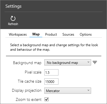
Map
Settings related to how maps behave in Maria Map Maker. These settings applies to your M3 client only - they do not have any effect on the products you produce.
Background map
Background map which is always displayed at the bottom of your maps. Two simple maps are included with Maria Map Maker, but you can use any map as a background through an external source.
Pixel scale
When zooming in, this determines how much a tile is enlarged before it is re-drawn at a higher resolution. A smaller number has the effect of making the map look sharper, at the cost of performance.
Tile cache size
The amount of memory in megabytes allowed for storing tiles for re-use. A higher number can increase performance when panning and zooming in a limited geographical area.
Display projection
The projection to use when displaying maps. The default option Mercator is equivalent to the Web mercator (EPSG:3857) projection.
Zoom to extent
Automatically zoom to extents when opening basemaps, overlays and elevation datasets.
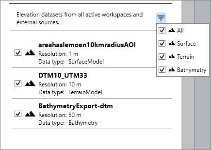
Elevation datasets
List of all elevation datasets available in your active workspaces and external sources. Datasets can be manually turned on or off, or filtered based on its type. These datasets are used as the basis for the elevation profile tool and shading when the map is in 2D mode. In 3D, they are used to model the terrain.
Product
Settings related to the Accompanying letter, which describes the contents of a product. The accompanying letter is created on the root of the product when it is released. It is an aggregation of metadata on each dataset, as well as the product itself.
Sources
Add an external Maria GDK server as a source. Any map data on the server will be available as background maps and elevation data in the section. The source URI should be on the form http://ip:port
Options
Settings related to the look and feel of the fixed windows in Maria Map Maker, such as the product window and basemap/overlay window. You can also change the path to use for temporary files when importing data. This setting requires the Apply Settings button to be used before it takes effect.

