Preparing S-57 hydrographic data
S-57 is the data format used for the transfer of digital hydrographic data between national hydrographic offices and for its distribution to manufacturers, mariners and other data users.
For a detailed reference on S-57 objects, attributes and codes, see http://www.s-57.com/
Translation step 1
ENC
Start FME workbench and open the supplied S-57.fmw workspace. Included in the translation from S-57 ENC data to M6M are two FME transformers - a selection filter and a coordinate extractor. Their task is to extract depth values from geometries referenced by S-57 SOUNDG records and put these values in a seperate attribute field, ZDEPTH, added for the purpose.
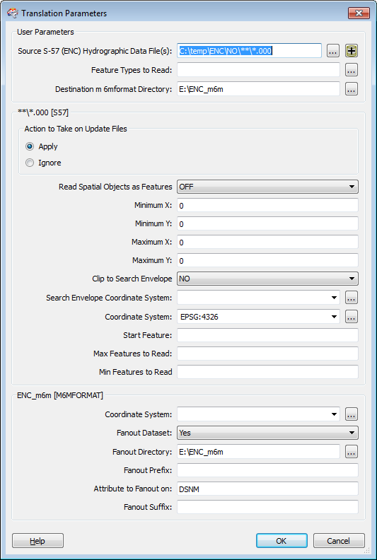
Select 'Edit Parameters...' from the Tools menu.
Use the navigation buttons or edit the content of 'Source S-57 (ENC) Hydrographic Data File(s):' - field to point to the location(s) of your ENC source data.
FME supports updates, files with extension .001, .002 ... containing successive corrections to a .000 file. For this to work, it is necessary that the updates are located in the same directory as the corresponding .000 file.
Use the navigation button or edit the content of the 'Fanout Directory: - field to point to a desired location for the output from this stage of the process. Note: Since we are using 'Fanout' with respect to dataset names (S-57 cell names) and thus explicitly stating a top level target folder, the 'Destination m6mformat Directory:' - parameter is immaterial.
Click 'OK' and run the translation process.
AML
For AML data, the workspace AML.fmw is used instead of S-57.fmw. Otherwise all instructions in this guide can be applied.
Translation step 2
Drawing of ENC charts is complex and needs specifically designed renderers. To assist drawing and minimize subsequent cross object lookups the output from the previous stage must pass through an additional filter. This is done with a separate command line utility S57filter.exe. Use as follows:
S57filter.exe <source folder> <target folder> [-r]
The <source folder> is the output folder from the previous stage. Use the -r option to traverse subdirectories.
Translation step 3
Create vectortiles. Use the script buildvectortiles_ENC_parallel_allfiles.ps1 on each of the datasets (with a separate target folder for each). Use the following zoomlevels:
| Dataset | Band | Zoomlevel |
|---|---|---|
| Overview | 1 | 3-14 |
| General | 2 | 10-13 |
| Coastal | 3 | 10-13 |
| Approach | 4 | 13-17 |
| Harbor | 5 | 14-17 |
| Berthing | 6 | 14-17 |
Finally, replace the .vtiles.sqlite files in the existing ENC map product.
