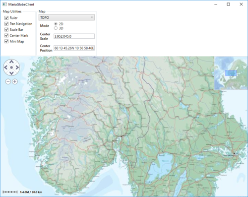
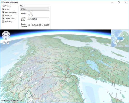
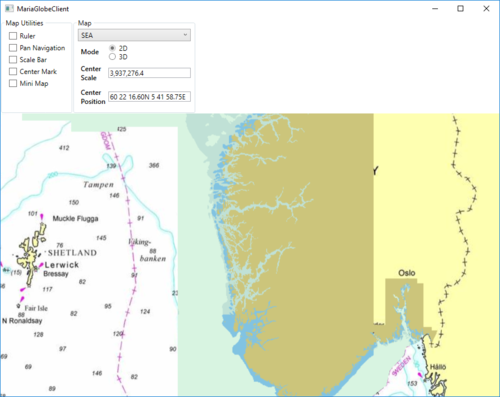
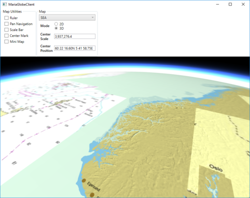
Maria globe client/Map interaction
Map utilities
The different map utilities can be turned on/off programatically e.g. through User controlls. For more details about tools and map functionality, see Map interaction client, Map_interaction and Tools interaction
Here is an example of adding check boxes with direct binding to the MariaGlobeMapControl from your main window.
...
<Grid>
    <Grid.RowDefinitions>
        <RowDefinition Height="auto"/>
        <RowDefinition Height="*"/>
    </Grid.RowDefinitions>
    <StackPanel Grid.Row="0" Orientation="Horizontal"
                Visibility="Visible">
        <GroupBox Header="Map Utilities">
            <StackPanel Orientation="Vertical" Visibility="Visible" Margin="5">
                <CheckBox Content="Ruler" Margin="3"
                          ToolTip="Ruler"
                          IsChecked="{Binding IsRulerVisible, ElementName=MariaGlobeCtrl}" />
                <CheckBox Content="Pan Navigation" Margin="3"
                          ToolTip="Pan Navigation"
                          IsChecked="{Binding IsPanNavigationVisible, ElementName=MariaGlobeCtrl}" />
                <CheckBox Content="Scale Bar" Margin="3"
                          ToolTip="Center Position, Scale Bar"
                          IsChecked="{Binding IsScaleBarVisible, ElementName=MariaGlobeCtrl}" />
                <CheckBox Content="Center Mark"  Margin="3"
                          ToolTip="Center Position Indicator"
                          IsChecked="{Binding IsCenterPositionIndicatorEnabled, ElementName=MariaGlobeCtrl}" />
                <CheckBox Content="Mini Map" Margin="3"
                          ToolTip="Mini Map"
                          IsChecked="{Binding IsMiniMapVisible, ElementName=MariaGlobeCtrl}" />
            </StackPanel>
        </GroupBox>
    </StackPanel>
    <Grid Grid.Row="1">
        <mariaglobemapcontrol:MariaGlobeMapControl x:Name="MariaGlobeCtrl"
                                                   Background="#E9ECFA"
                                                   Layers="{Binding Layers}"
                                                   MiniMapLayer="{Binding MapViewModel.MiniMapLayer, Mode=OneWay}"
                                                   CenterScale="{Binding MapViewModel.CenterScale}"
                                                   CenterPosition="{Binding MapViewModel.CenterPosition}"
                                                   Is3DMode="False"
                                                   MouseMoveDistanceToStartTracking="0"
                                                   ZoomOnDblClick="False"
                                                   DegreeToLockRotateAndScale="2"
                                                   PercentageToLockScaleOnly="2.0"
                                                   IsRulerVisible="True"
                                                   IsCenterPositionIndicatorEnabled="True"
                                                   IsMiniMapVisible="True" />
    </Grid>
</Grid>
...
Map settings
Your map service will most likely contain different map templates, and you would like to select the template to be used.
In we will create a list of templates to chose from, display the current center position and scale, and also choose the display mode - 2D or 3D.
Add the following to your Main Window XAML:
...
<GroupBox Header="Map Settings">
    <Grid Margin="3">
        <Grid.RowDefinitions>
            <RowDefinition Height="auto" />
            <RowDefinition Height="auto" />
            <RowDefinition Height="auto" />
            <RowDefinition Height="auto" />
        </Grid.RowDefinitions>
        <Grid.ColumnDefinitions>
            <ColumnDefinition Width="auto"/>
            <ColumnDefinition Width="*"/>
        </Grid.ColumnDefinitions>
        <ComboBox Name="cmbActiveMap" Grid.Row="0" Grid.Column="0" Grid.ColumnSpan="2" Margin="0,0,0,5"
                  Width="Auto" Height="Auto" MinWidth="200"
                  VerticalAlignment="Top"
                  ItemsSource="{Binding MapViewModel.AvailableMapTemplateNames}"
                  SelectedItem="{Binding MapViewModel.ActiveMapTemplateName}"
                  IsSynchronizedWithCurrentItem="true" />

        <Label Grid.Row="1" Grid.Column="0"
               Content="Mode" FontWeight="DemiBold"/>
        <StackPanel Grid.Row="1" Grid.Column="1">
                <RadioButton Content="2D"
                             IsChecked="{Binding MapViewModel.Is2DMode, Mode=OneWay}" />
                <RadioButton Content="3D"
                             IsChecked="{Binding MapViewModel.Is3DMode}" />
        </StackPanel>

        <Label Grid.Row="2" Grid.Column="0"  FontWeight="DemiBold">
            <TextBlock>
                Center<LineBreak/>
                Scale
            </TextBlock>
        </Label>
        <TextBox Grid.Row="2" Grid.Column="1" VerticalAlignment="Center"
                 Text="{Binding MapViewModel.CenterScale, StringFormat=N1}"
                 IsReadOnly="True" />

        <Label Grid.Row="3" Grid.Column="0"  FontWeight="DemiBold">
            <TextBlock>
                Center<LineBreak/>
                Position
            </TextBlock>
        </Label>
        <TextBox Grid.Row="3" Grid.Column="1" VerticalAlignment="Center"
                 Text="{Binding MapViewModel.CenterPosition, Mode=OneWay}"
                 IsReadOnly="True" />
    </Grid>
</GroupBox>
...
And bind the Is3DMode property of the MariaGlobeMapControl to same value as the Radio button.
...
<mariaglobemapcontrol:MariaGlobeMapControl x:Name="MariaGlobeCtrl" Background="#E9ECFA"
                                           Is3DMode="{Binding MapViewModel.Is3DMode}"
                                           Layers="{Binding Layers}"
...
Extend the MapViewModel with:
- fields and properties to handle display of available map templates and 2D/3D mode selection
- initialized event handlers with initialisation and selection of templates
- CenterPosition and CenterScale properties with notification handling.
...
private Dictionary<string, MapTemplate> _availableMapTemplateDictionary = new Dictionary<string, MapTemplate>();

private double _scale;
private GeoPos _pos;
private bool _is3DMode;
...
public bool Is2DMode { get { return !_is3DMode; } }

public bool Is3DMode
{
    get { return _is3DMode; }
    set
    {
        _is3DMode = value;
        NotifyPropertyChanged(() => Is2DMode);
        NotifyPropertyChanged(() => Is3DMode);
    }
}

public GeoPos CenterPosition
{
    get { return _pos; }
    set
    {
        _pos = value;
        NotifyPropertyChanged(() => CenterPosition);
    }
}

public double CenterScale
{
    get { return _scale; }
    set
    {
        _scale = value;
        NotifyPropertyChanged(() => CenterScale);
    }
}

public MapViewModel(IMariaMapLayer mapLayer, IMariaMapLayer miniMapLayer)
{
    _mapLayer = mapLayer;

    if (_mapLayer != null)
        _mapLayer.LayerInitialized += OnMapLayerInitialized;

    MiniMapLayer = miniMapLayer;
    if (MiniMapLayer != null)
        MiniMapLayer.LayerInitialized += OnMiniMapLayerInitialized;
}

private void OnMapLayerInitialized()
{
    foreach (var template in _mapLayer.ActiveMapTemplates)
    {
        _availableMapTemplateDictionary.Add(template.Name, template);
    }

    NotifyPropertyChanged(() => AvailableMapTemplateNames);

    CenterPosition = new GeoPos(59.908358, 10.628190); // TPG - Lysaker
    CenterScale = 3500000;

    _mapLayer.ActiveMapTemplate = _mapLayer.ActiveMapTemplates.Any() ?
                                    _mapLayer.ActiveMapTemplates.First() : null;

    _mapLayer.ActiveMapTemplate = PreferredMapTemplate();
    NotifyPropertyChanged(() => ActiveMapTemplateName);
}

private void OnMiniMapLayerInitialized()
{
    MiniMapLayer.ActiveMapTemplate = _mapLayer.ActiveMapTemplates.Any() ?
                                    _mapLayer.ActiveMapTemplates.First() : null;
    MiniMapLayer.ActiveMapTemplate = PreferredMapTemplate();
}


public IEnumerable<string> AvailableMapTemplateNames
{
    get
    {
        return _availableMapTemplateDictionary.Keys.ToList();
    }
}

public string ActiveMapTemplateName
{
    get
    {
        if (_mapLayer != null && _mapLayer.ActiveMapTemplate != null)
            return _mapLayer.ActiveMapTemplate.Name;
        return "";
    }
    set
    {
        MapTemplate template = null;

        if (_availableMapTemplateDictionary.ContainsKey(value))
        {
            template = _availableMapTemplateDictionary[value];
        }
        else if (_availableMapTemplateDictionary.Any())
        {
            template = _availableMapTemplateDictionary.Values.First();
        }

        _mapLayer.ActiveMapTemplate = template;
        MiniMapLayer.ActiveMapTemplate = template;
        NotifyPropertyChanged(() => ActiveMapTemplateName);
    }
}

private MapTemplate PreferredMapTemplate()
{
    var preferred = "TOPO";

    if (_availableMapTemplateDictionary.ContainsKey(preferred))
        return _availableMapTemplateDictionary[preferred];

    return _availableMapTemplateDictionary.Values.Any() ? _availableMapTemplateDictionary.Values.First() : null;
}
...
Running with map interaction
Running your application, observe the following:
- the map utilities are shown/hidden according to the corresponding check boxes
- the center position and scale are updated when panning/zooming the map
- the map template drop-down list contains available map templates
- the map display changes according to selected map template
- the map display changes according to deleted mode


