Elevation analysis client
This section describes how to create a map client utilising Maria elevation analysis functionality.
Maria provides graphical display of elevation information, by utilising Maria Elevation Analysis layer with elevation observer tools.
General
The application is based on a map component corresponding to Maria Basic Map Client, with additional map selection and tools.
- Note
-
- You will need to include the TPG.MariaGDK NuGet package.
- For more info, see Loading Maria GDK, NuGet Packages
- Sample code for this example is found in the MariaElevationAnalysis project, in MariaAdditionalComponents folder of the Sample Projects solution.
- For troubleshooting, see Development troubleshooting
Creating Elevation Observers
We will now perform interactions towards the elevation analysis layer through the elevation analysis layer interface, IMariaElevationAnalysisLayer.
Create a view model class (ElevationAnalysisViewModel.cs) for interaction with the elevation analysis layer, inheriting ViewModelBase, and with the elevation analysis layer as parameters to the constructor.
Add an event handler for the elevation analysis layer LayerInitialized event, populating the layer with a "Line Of Sight Observer" and a "Max/Min Elevation Observer".
private IMariaElevationAnalysisLayer _elevationAnalysisLayer;

public ElevationAnalysisViewModel(IMariaElevationAnalysisLayer elevationAnalysisLayer)
{
    _elevationAnalysisLayer = elevationAnalysisLayer;
    _elevationAnalysisLayer.LayerInitialized += OnElevationAnalysisLayerInitialized;
}
private void OnElevationAnalysisLayerInitialized()
{
    var LineOfSightObserverData = new LineOfSightObserverData(Guid.NewGuid().ToString())
                                      {
                                          Position = new GeoPos(60, 9.2),
                                          Range = 20000
                                      };
    _elevationAnalysisLayer.Observers.Add(LineOfSightObserverData);

    var MaxMinElevationObserverData = new MaxMinElevationObserverData(Guid.NewGuid().ToString())
                                          {
                                              Position = new GeoPos(60, 10.2),
                                              Range = 30000
                                          };
    _elevationAnalysisLayer.Observers.Add(MaxMinElevationObserverData);
}
Then, create the Elevation Analysis Layerand include the ElevationAnalysisViewModel in the declarations and constructor of the main view model (MariaWindowViewModel).
public ElevationAnalysisViewModel ElevationAnalysisViewModel { get; private set; }
private readonly IMariaElevationAnalysisLayer _elevationAnalysisLayer;
. . .
_elevationAnalysisLayer = new MariaElevationAnalysisLayer(_mapLayer.MapResources);
ElevationAnalysisViewModel = new ElevationAnalysisViewModel(_elevationAnalysisLayer);
Layers.Add(_elevationAnalysisLayer);
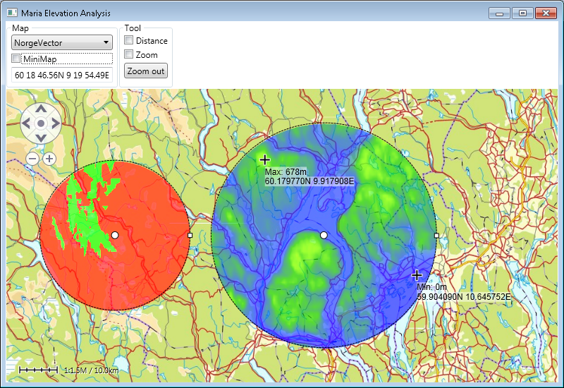
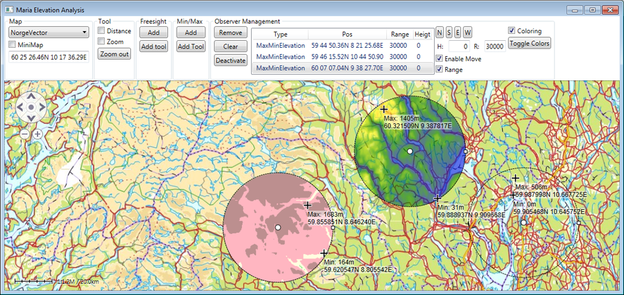
Running your application, you will have a map looking something like this, with one free sight observer and one min/max elevation observer.
Note!
Observe that you can move the observers around by dragging the center point -- and alter the range by dragging the handle on the right side of the observer.
Elevation observer tools
Add buttons for adding observer by position and by tool to your main window xaml:
<Button Name="AddFreesight" Margin="2"
    Content="Add" ToolTip="Add Freesight Observer"
    Command="{Binding ElevationAnalysisViewModel.AddFreesightObserverCommand}"
    />
<Button Name="AddFreesightTool" Margin="2"
    Content="Add tool" ToolTip="Add Freesight Observer by tool"
    Command="{Binding ElevationAnalysisViewModel.AddFreesightObserverToolCommand}"
    />
Add command handlers to the buttons in the elevation analysis view model:
public ICommand AddFreesightObserverCommand
{
    get { return new DelegateCommand(x => AddLinOfSightObserver()); }
}
public ICommand AddFreesightObserverToolCommand
{
    get
    {
        return
            new DelegateCommand(x =>
               _elevationAnalysisLayer.ActivateCreationWorkflow(ObserverType.LineOfSight));
    }
}
private void AddLinOfSightObserver()
{
    var data = new LineOfSightObserverData(Guid.NewGuid().ToString())
    {
        Position = RandomProvider .GetRandomPosition(
                     _elevationAnalysisLayer.GeoContext.Viewport.GeoRect),
        Range = 20000
    };
    _elevationAnalysisLayer.Observers.Add(data);
}
Do the same for the Max/Min Elevation observer, and remove the creation of objects from the initialization method.
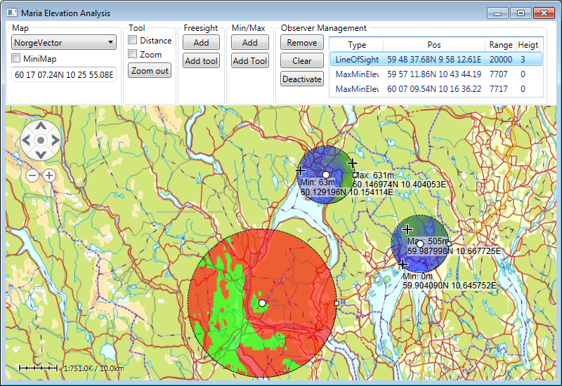
You will now be able to add observers at specific & random positions.
Note!
The range of observers added by the observer tool will be adjusted according to the displayed map area.
Managing Elevation Observers
We shall now manage all the observers commonly, adding "Remove", "Clear" and buttons, and a list view displaying all observers.
Add the buttons and a list view to your main window xaml:
<Button Name="RemoveObserverCmd" Margin="2"
        Content="Remove" ToolTip="Remove Selected Observer"
        Command="{Binding ElevationAnalysisViewModel.RemoveObserverCommand}"
        />
<Button Name="ClearObserversCmd" Margin="2"
        Content="Clear" ToolTip="Clear Observers"
        Command="{Binding ElevationAnalysisViewModel.ClearObserversCommand}"
        />
<Button Name="DeactivateCmd" Margin="2"
        Content="Deactivate" ToolTip="Deactivate Observer Tool"
        Command="{Binding ElevationAnalysisViewModel.DeactivateCommand}"
        />
. . .
<ListView Grid.Column="1" Margin="5, 5, 0, 5"  MaxHeight="150"
          Name="ObserversView"
          ItemsSource="{Binding ElevationAnalysisViewModel.Observers}"
          SelectedItem="{Binding ElevationAnalysisViewModel.SelectedObserver}"
          SelectionMode="Single">
    <ListView.View>
        <GridView>
            <GridViewColumn Header="Type"
                DisplayMemberBinding="{Binding ObserverType}"/>
            <GridViewColumn Header="Pos"
                DisplayMemberBinding="{Binding Position}"/>
            <GridViewColumn Header="Range"
                DisplayMemberBinding="{Binding Range}"/>
        </GridView>
    </ListView.View>
</ListView>
Then implement command handlers and other necessary properties in the view model:
public ICommand RemoveObserverCommand
        {
            get { return new DelegateCommand(x => OnRemoveObserverCmd()); }
        }
private void OnRemoveObserverCmd()
{
    if (IsObserverSelected)
    {
        _elevationAnalysisLayer.Observers.Remove(_selectedObserver);
    }
}
public ICommand ClearObserversCommand
        {
            get { return new DelegateCommand(x => OnClearObserversCmd()); }
        }
private void OnClearObserversCmd()
        {
            _elevationAnalysisLayer.Observers.Clear();
        }
public ObservableCollection<IObserverData> Observers
{
    get
    {
        return _elevationAnalysisLayer.Observers;
    }
}
public ICommand DeactivateCommand
{
    get { return new DelegateCommand(x => OnDeactivateCmd()); }
}
private void OnDeactivateCmd()
{
     _elevationAnalysisLayer.DeactivateCreationWorkflow();
}
private IObserverData _selectedObserver;
public IObserverData SelectedObserver
{
    get
    {
        return _selectedObserver;
    }
    set
    {
        _selectedObserver = value;

        NotifyPropertyChanged(() => SelectedObserver);
        NotifyPropertyChanged(() => IsObserverSelected);
    }
}
public bool IsObserverSelected
{
    get
    {
        return _selectedObserver != null;
    }
}
In the LayerInitialized event handler, add an event handler for the elevation analysis layers IMariaElevationAnalysisLayer.Observers.CollectionChanged event.
private void OnElevationAnalysisLayerInitialized()
{
    _elevationAnalysisLayer.Observers.CollectionChanged
                                      += OnObserversCollectionChanged;
    . . .
}
private void OnObserversCollectionChanged(object sender,
                                          NotifyCollectionChangedEventArgs e)
{
    NotifyPropertyChanged(() => Observers);
}
- You should now be able to examine your observers in the list view, remove selected observer or clear all.
- You should also be able to deactivate ongoing "Add tool" commands.
Observer properties alterations
The generic observer properties are reached through IObserverData -- Free sight observers through ILineOfSightObserverData, and max/min observers through IMaxMinElevationObserverData.
We will work with the currently selected object.
Generic properties
Add the following properties and command handlers to the view model:
public ICommand StepNorth { get { return new DelegateCommand(x => Move(0.1, 0)); }}
public ICommand StepSouth { get { return new DelegateCommand(x => Move(-0.1,0)); }}
public ICommand StepEast  { get { return new DelegateCommand(x => Move(0,0.1)); }}
public ICommand StepWest  { get { return new DelegateCommand(x => Move(0,-0.1)); }}
private void Move(double lat, double lon)
{
   if (_selectedObserver != null)
   {
       _selectedObserver.Position = new GeoPos(_selectedObserver.Position.Lat + lat,
                                               _selectedObserver.Position.Lon + lon);
       _elevationAnalysisLayer.UpdateObserver(_selectedObserver);
   }
}
public double SelectedHeightAboveGround
{
    get { return  _selectedObserver != null ? _selectedObserver.HeightAboveGround : 0; }
    set
    {
        if (_selectedObserver != null)
        {
            _selectedObserver.HeightAboveGround = value;
            _elevationAnalysisLayer.UpdateObserver(_selectedObserver);
        }
    }
}
public int SelectedRange
{
    get { return _selectedObserver != null ? _selectedObserver.Range : 0; }
    set
    {
        if (_selectedObserver != null)
        {
            _selectedObserver.Range = value;
            _elevationAnalysisLayer.UpdateObserver(_selectedObserver);
        }
    }
}
public bool EnableSelectedInteractiveMove
{
    get { return _selectedObserver != null && _selectedObserver.EnableInteractiveMove; }
    set { if (_selectedObserver != null) _selectedObserver.EnableInteractiveMove = value; }
}
public bool EnableSelectedInteractiveRadius
{
    get { return _selectedObserver != null && _selectedObserver.EnableInteractiveRadius; }
    set { if (_selectedObserver != null)  _selectedObserver.EnableInteractiveRadius = value; }
}
Then, add the following to your window xaml, and bind to the view model properties:
<StackPanel Orientation="Horizontal">
    <Button Content="N" Margin="2" Command="{Binding ElevationAnalysisViewModel.StepNorth}"/>
    <Button Content="S" Margin="2" Command="{Binding ElevationAnalysisViewModel.StepSouth}"/>
    <Button Content="E" Margin="2" Command="{Binding ElevationAnalysisViewModel.StepEast}"/>
    <Button Content="W" Margin="2" Command="{Binding ElevationAnalysisViewModel.StepWest}"/>
</StackPanel>
<StackPanel Orientation="Horizontal">
    <Label Content="H: " />
    <TextBox Name="FreesightHeigt" Width="40" TextAlignment="Right" Margin="2"
             Text="{Binding ElevationAnalysisViewModel.SelectedHeightAboveGround}"
             />
    <Label Content="R: " />
    <TextBox Width="40" TextAlignment="Right" Margin="2"
             Text="{Binding ElevationAnalysisViewModel.SelectedRange}"
             />
</StackPanel>
<CheckBox Name="ChkEnableInteractiveMove" Margin="2"
          Content="Enable Move" ToolTip="Enable Interactive Move"
          IsChecked="{Binding ElevationAnalysisViewModel.EnableSelectedInteractiveMove}" />
<CheckBox Name="ChkEnableInteractiveRadius" Margin="2"
          Content="Range" ToolTip="Enable Interactive Radius"
          IsChecked="{Binding ElevationAnalysisViewModel.EnableSelectedInteractiveRadius}" />
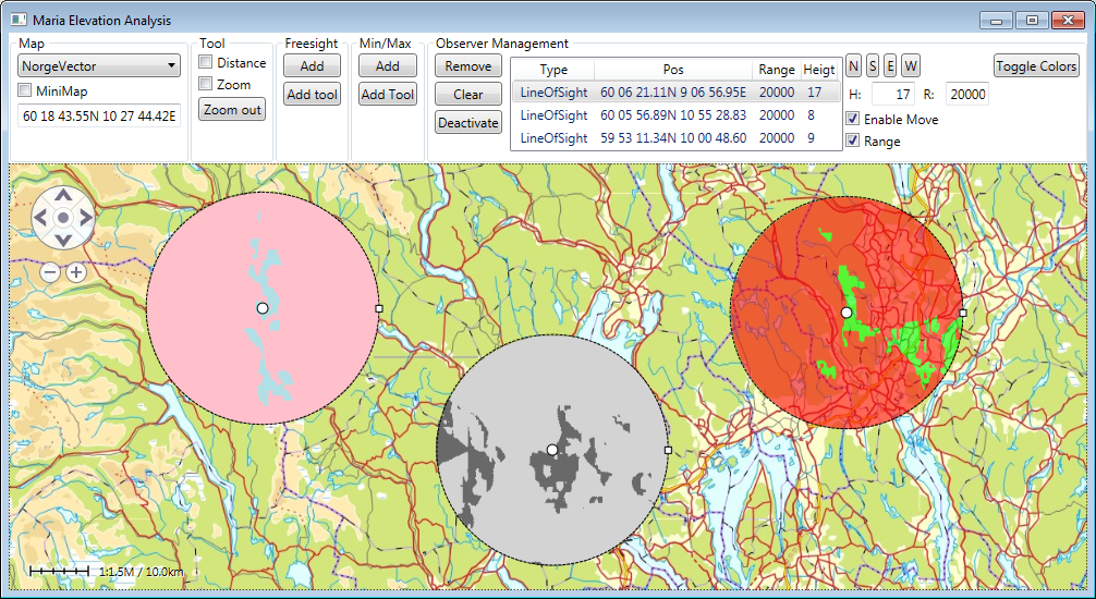
You should now be able to change the range, position and height level of the selected observer, and disable change by dragging center points and range handles.
Note!
Observe that you still can change size and position from your GUI.
Free sight observers
Free sight observers are reached through ILineOfSightObserverData, with two additional properties, HiddenColor and VisibleColor.
Add a button to initiate change of color . . .
<Button Content="Toggle Colors" ToolTip="Toggle Selected Observer Colors" Margin="2"
        Command="{Binding ElevationAnalysisViewModel.ToggleSelectedColorsCommand}"
        />
. . . with command handler:
public ICommand ToggleSelectedColorsCommand
{
    get { return new DelegateCommand(x => OnToggleSelectedColorsCommand()); }
}
private void OnToggleSelectedColorsCommand()
{
    if (_selectedObserver.ObserverType == ObserverType.LineOfSight)
    {
        var freesightObserver = (ILineOfSightObserverData) _selectedObserver;

        if (freesightObserver.HiddenColor == Colors.Pink)
        {
            freesightObserver.HiddenColor = Colors.LightGray;
            freesightObserver.VisibleColor = Colors.DimGray;
        }
        else if (freesightObserver.HiddenColor == Colors.LightGray)
        {
            var temp = new LineOfSightObserverData("x");
            freesightObserver.HiddenColor = temp.HiddenColor;
            freesightObserver.VisibleColor = temp.VisibleColor;
        }
        else
        {
            freesightObserver.HiddenColor = Colors.Pink;
            freesightObserver.VisibleColor = Colors.PowderBlue;
        }
    }

    _elevationAnalysisLayer.UpdateObserver(_selectedObserver);
}
By pressing the button, the hidden/visible will change between the two sets of colors (and the default colors (Pink/PowderBlue and LightGray/DimGray) and the default colors.
Max/min observers
Max/min observers are reached through IMaxMinElevationObserverData, with two additional properties, Legend and IsElevationColoringEnabled.
Add a checkbox to manage enable/disable elevation coloring. We will use the button from the previous section to change legend color sets:
<CheckBox Name="ChkElevationColoringEnabled" Margin="2"
          Content="Coloring" ToolTip="Enable Elevation Coloring"
          IsChecked="{Binding ElevationAnalysisViewModel.IsElevationColoringEnabled}"
          Visibility="{Binding ElevationAnalysisViewModel.ColoringVisibility}" />
Add properties to handle elevation coloring, and extend the button command handler to handle legend update:
private void OnToggleSelectedColorsCommand()
{
    var maxMinObserver = (IMaxMinElevationObserverData) _selectedObserver;

    if (_selectedObserver.ObserverType == ObserverType.LineOfSight)
   . . .
    else if (_selectedObserver.ObserverType == ObserverType.MaxMinElevation)
    {
        var legend = new ElevationLegend();

        if (maxMinObserver.Legend.Items.Count == legend.Items.Count)
        {
            legend.Items = new ObservableCollection<IElevationLegendItem>
                               {
                                   new ElevationLegendItem(-1000, Colors.Transparent, 1, Colors.Transparent),
                                   new ElevationLegendItem(1, Colors.LightGreen, 200, Colors.LightGreen),
                                   new ElevationLegendItem(200, Colors.LightYellow, 500, Colors.LightYellow),
                                   new ElevationLegendItem(500, Colors.LightPink, 1000, Colors.LightPink),
                                   new ElevationLegendItem(1000, Colors.RosyBrown, 800, Colors.RosyBrown)
                               };
        }
        maxMinObserver.Legend = legend;
    }
    _elevationAnalysisLayer.UpdateObserver(_selectedObserver);
}
. . .
public bool IsElevationColoringEnabled
{
    get
    {
        if (_selectedObserver != null && _selectedObserver.ObserverType == ObserverType.MaxMinElevation)
            return ((IMaxMinElevationObserverData)_selectedObserver).IsElevationColoringEnabled;
        return true;
    }
    set
    {
        if (_selectedObserver != null && _selectedObserver.ObserverType == ObserverType.MaxMinElevation)
        {
            ((IMaxMinElevationObserverData)_selectedObserver).IsElevationColoringEnabled = value;
            _elevationAnalysisLayer.UpdateObserver(_selectedObserver);
        }
    }
}
public Visibility ColoringVisibility { get { return SelectedIsMaxMinObserver ? Visibility.Visible : Visibility.Collapsed; } }
By pressing the button change between the and the default legend and the alternative legend. Unchecking the check box removes coloring.
Note!
The default legend has convergent coloring, while the alternative legend has uniform coloring for each elevation range.
