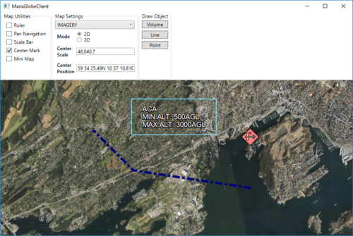
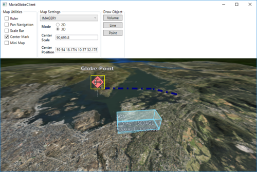
Maria globe client/Draw object interaction
General
In this section, we will create and update three different draw objects, a area object, a line object, and a point object, and see how they are presented in 2D and 3D mode.
For more details on draw object handling, see:
- Draw objects
- Map interaction client:
Adding draw object layer and draw object view model
To be able to display draw objects, we need to include a draw object layer in the globe client.
First, add a view model class, DrawObjectViewModel, to handle the draw object interaction:
- Inheriting ViewModelBase
- Add a constructor taking a draw layer object as input
- Create and implement event handlers for:
- LayerInitialized event
- ServiceConnected event
public class DrawObjectViewModel : ViewModelBase
{
    private IMariaDrawObjectLayer _drawObjectLayer;
    private IMariaService _drawObjectService;

    public DrawObjectViewModel(DrawObjectLayer drawObjectLayer)
    {
        _drawObjectLayer = drawObjectLayer;
        _drawObjectLayer.LayerInitialized += DrawObjectLayer_LayerInitialized;
        _drawObjectLayer.ServiceConnected += DrawObjectLayer_ServiceConnected;
    }

    private void DrawObjectLayer_LayerInitialized()
    {
        _drawObjectService = new MariaService(
            "DrawObjectService",
            "http://localhost:9008/drawobjects",
            BindingType.BasicHttp);

        _drawObjectLayer.DrawObjectServices = new ObservableCollection<IMariaService> { _drawObjectService };

        _drawObjectLayer.CreateDrawObjectList("local", true);
    }

    private void DrawObjectLayer_ServiceConnected(object sender, MariaServiceEventArgs args)
    {
        _drawObjectLayer.ActiveDrawObjectService = _drawObjectLayer.DrawObjectServices[0];

        _drawObjectLayer.CreateDrawObjectList("test", false);
        _drawObjectLayer.ActiveDrawObjectList = "test";
    }
}
In the MainViewModel, add a draw object layer field, and in the constructor, add creation of the layer and DrawObjectViewModel and add the layer to the Layers list.
...
public DrawObjectViewModel DrawObjectViewModel { get; private set; }

public MainViewModel()
{
    ...
    DrawObjectLayerFactory = new DrawObjectLayerFactory();
    _drawObjectLayer = new DrawObjectLayer(GlobeMapManager, DrawObjectLayerFactory, true)
        { InitializeCreationWorkflows = true };
    DrawObjectViewModel = new DrawObjectViewModel(_drawObjectLayer);
    Layers.Add(_drawObjectLayer);
}
...
Draw object utilities
Add the following GUI elements to your main window:
- Button for adding/updating a volume object.
- Button for adding/updating a line object.
- Button for adding/updating a point object.
The XAML could look something like this:
...
<GroupBox Header="Draw Object" >
    <StackPanel VerticalAlignment="Top">
        <Button Margin="3"
                Content="Volume"
                Command="{Binding DrawObjectViewModel.VolumeTestCmd}"/>
        <Button Margin="3"
                Content="Line"
                Command="{Binding DrawObjectViewModel.LineTestCmd}"/>
        <Button Margin="3"
                Content="Point"
                Command="{Binding DrawObjectViewModel.PointTestCmd}"/>
    </StackPanel>
</GroupBox>
...
Implement command handler and command handler delegate in DrawObjectViewModel.
...
public ICommand VolumeTestCmd { get { return new DelegateCommand(DrawObjectViewModel.CreateOrUpdateVolumeObject); } }
public ICommand LineTestCmd { get { return new DelegateCommand(DrawObjectViewModel.CreateOrUpdateLineObject); } }
public ICommand PointTestCmd { get { return new DelegateCommand(DrawObjectViewModel.CreateOrUpdatePointObject); } }

public void CreateOrUpdatePointObject(object obj)
{
    var pos = RandomProvider.GetRandomPosition(_drawObjectLayer.GeoContext.Viewport.GeoRect);

    var altitude = RandomProvider.GetRandomInt(1, 5) * 500.0;

    var pointObject = _drawObjectLayer.DrawObjectFactory.CreateTacticalGraphic("STBOPS.OPN.HJKG.APL");
    pointObject.TacticalDataFields.StandardIdentity = StandardIdentity.Hostile;
    pointObject.TacticalDataFields.Name = "Globe-Point";
    pointObject.Id = new ItemId("local", "Globe-Point");

    pointObject.Points[0] = new GeoPoint() { Latitude = pos.Lat, Longitude = pos.Lon, Altitude = altitude };
    _drawObjectLayer.UpdateStore(pointObject);
}

public void CreateOrUpdateVolumeObject(object obj)
{

    var volumeObject = _drawObjectLayer.DrawObjectFactory.CreateTacticalGraphic("TACGRP.FSUPP.ARS.C2ARS.ACA.IRR");
    volumeObject.TacticalDataFields.StandardIdentity = StandardIdentity.Friendly;
    volumeObject.Id = new ItemId("local", "Globe-Volume");

    var pos = RandomProvider.GetRandomPosition(_drawObjectLayer.GeoContext.Viewport.GeoRect, 0.8);
    var factorLat = _drawObjectLayer.GeoContext.Viewport.GeoRect.DeltaLat * RandomProvider.GetRandomDouble(0.05, 0.1);
    var factorLon = _drawObjectLayer.GeoContext.Viewport.GeoRect.DeltaLon * RandomProvider.GetRandomDouble(0.05, 0.1);

    volumeObject.Points = new GeoPoint[] {
        new GeoPoint() { Latitude = pos.Lat + factorLat, Longitude = pos.Lon + factorLon },
        new GeoPoint() { Latitude = pos.Lat + factorLat, Longitude = pos.Lon - factorLon },
        new GeoPoint() { Latitude = pos.Lat - factorLat, Longitude = pos.Lon - factorLon },
        new GeoPoint() { Latitude = pos.Lat - factorLat, Longitude = pos.Lon + factorLon },
    };

    _drawObjectLayer.UpdateStore(volumeObject);
}

public void CreateOrUpdateLineObject(object obj)
{
    var lineObject = _drawObjectLayer.DrawObjectFactory.CreatePolyLine(new ItemId("local", "Globe-Line"));
    var pt0 = RandomProvider.GetRandomPosition(_drawObjectLayer.GeoContext.Viewport.GeoRect, 0.5);
    var pt1 = RandomProvider.GetRandomPosition(_drawObjectLayer.GeoContext.Viewport.GeoRect, 0.5);
    var pt2 = RandomProvider.GetRandomPosition(_drawObjectLayer.GeoContext.Viewport.GeoRect, 0.5);

    lineObject.Points = new GeoPoint[] {
        new GeoPoint() { Latitude = pt0.Lat, Longitude = pt0.Lon, Altitude = RandomProvider.GetRandomInt(1, 5) * 500.0 },
        new GeoPoint() { Latitude = pt1.Lat, Longitude = pt1.Lon, Altitude = RandomProvider.GetRandomInt(1, 5) * 500.0 },
        new GeoPoint() { Latitude = pt2.Lat, Longitude = pt2.Lon, Altitude = RandomProvider.GetRandomInt(1, 5) * 500.0 },
    };

    lineObject.GenericDataFields.LineColor = Colors.Navy;
    var dashStyle = DashStyles.DashDot;
    lineObject.GenericDataFields.LineDashStyle = dashStyle.Dashes.ToList();
    lineObject.GenericDataFields.LineDashStyleOffset = dashStyle.Offset;
    lineObject.GenericDataFields.LineWidth = 6.0;

    _drawObjectLayer.UpdateStore(lineObject);
}
...
The RandomProvider class is described in context with Map interaction client, track creation.
Draw object styling
Add a draw object style xml file to your project, and include it as a resource.
Add the resource to the draw object layer in the LayerInitialized event handler in DrawObjectViewModel.
...
private void DrawObjectLayer_LayerInitialized()
{
    _drawObjectLayer.StyleXml = Properties.Resources.DrawObjectStyle;
...
Running with draw object interaction
Running your application, observe the following:
- Pressing the draw object buttons, draw objects created / moved around in the map area.
- In 2D mode, the objects can also be selected and moved/resized manually.

